Everest Base Camp Trekking Route

Everest Base Camp Trek is the one of the Famous trekking route in Nepal , From Everest base camp trekking Route you can see world Highest mountain MT everest and other many highest mountain you can see which is really lifetime achievement in your life . For further information you can click this link

1/12/2016

Trekking equipment for Everest Base camp trekking route

During The travelling time you need to Check your equipment list , Same as Nepal trekking or visiting time you Need to manage your equipment for your easy and comfortable Journey . Here I give you  some suggestion packing list : 

Equipments List:

  • Down Sleeping Bag,
  • Down Jacket
  • Long sleeved shirt
  • Jumper or fleecy jacket
  • 3++T - shirts 
  • Trekking shoes or boots
  • Comfy shoes for around the camp
  • Polypropylene/wool socks,
  • Light cotton socks
  • Rucksack 
  • Sun hat,
  • Woolen hat,
  • Gloves ,
  • Sun block for Faces and Lips 
  • Goggles or sunglasses,
  • Long underwear,
  • Insulated pant,s / Nylon windbreaker,
  • Nylon wind pants,
  • Water bottle,
  • Sewing kit,
  • Medical & first aid kit,
  • Flash light,
  • Batteries and bulbs
  • Towel and toiletries

What to Bring more Details:

Sleeping bag
Down-filled bags are better. Beg, borrow or steal a good one (i.e. 4-5 season) because high altitude nights will be cool. Good down is fluffy, light and thick. A muff (an extra section around the neck) makes a big difference to the overall warmth of a bag. Reasonable sleeping bags are cheaply available for rent in Kathmandu. Alternatively add a fleece sleeping bag liner to add warmth to a 3-4 season bag.

Sleeping bag liner
Cotton, silk or fleece saves washing your sleeping bag and adds warmth.

Fleece jacket
Mostly trekkers consider this essential but alternatives are a thick thermal top or a light down jacket. In Kathmandu you can get almost any sort of copy fleece you need, but for good quality you can purchase on your home. 
Down jacket/Gore-Tex
Down jacket is really needed for the 2 weeks trek although trekking up to 3000m also cold in the evening and morning. If you don’t have it and wanted to use for only Nepal trekking you can rented in Kathmandu in less than a dollar.

Rain Jacket/ Wind Shell:
The jacket should be very water repellent and roomy. Coated nylon or a waterproof/breathable fabric such as Gore-tex, a nylon or synthetic; can be used as a both rain and a wind jacket

Day-wear T-shirts/Shirts
On the lower altitude trekking weather will be hot, T-shirts and shirts are recommended

Thermal shirts/underwear
Good thermals, both tops and bottoms are the best for cold weather in trekking 
Nightwear thermals
Good for making warm nights in the sleeping bag, Silk-weight is lightest and warm,
Fleece/sweatpants
Good for the cold evening and morning

Footwear:

One pair of sturdy light to middleweight hiking boots is necessary. Typically these are combination of nylon and leather. We suggest boots with a Gore-tex lining to be waterproof. These types of shoes have a lug sole for good traction and provide lateral support for the ankles that is essential while hiking (for example; the Vasque Clarion and the Asolo Approach). Heavy-weight all-leather backpacking boots are not recommended. Be sure your footwear is broken in and fits well. Boots should fit comfortably over one thin liner sock and a mid-weight wool sock. This reduces chafing and blisters. Tennis shoes or sandals are also useful for in camp use or bathing.

Camp shoes/sandals/flip-flops
Some times are necessary for showers and Dining room  
Socks:
Four pairs of liner socks and four pairs of mid-weight wool socks to be carried. Socks and footwear should be coordinated for a proper fit.

Back pack
If you plan on trekking, a sturdy and comfortable back pack and day pack would be much more comfortable than suitcase. You should have your back pack expertly fitted to you. Your backpack should also have a waterproof cover.
Daypack
This should be comfortable and a good waist band that transfers some of the weight to the hips is most important. It needs to be big enough to take a jacket, fleece, water, camera and odds and ends. Kathmandu now offers a range of cheap fall-part packs to top of the range.

Sun hat/woolen hat
You can bring the hat or small cap to protect from day Sunburn. On the upper part of trek more cold and windy so you can have woolen hat to make your head warmer.
Mittens/gloves
A good pair of wind-proof gloves is essential. You can buy in Kathmandu cheap if you don’t have it. 
Neck gaiter
Nice for winter trekking, they are really the best for staying warm.

Sunglasses
Good wraparound glasses suitable for snow, it's bright up there, but specialized glacier glasses with side pieces are not needed. Contact lens wearers report very few problems except cleaning them in the conditions.

Trekking pants
Recommended having 2 pairs
Wind pants
If your trekking pants are reasonably windproof then special wind pants are not needed. If you do bring a pair, it is not necessary to have Gore-tex or similar non-waterproof.
Underwear :
Regular everyday type. 
Sunscreen and lip balm with sunscreen
Bring at least sunscreen and lip balm with SPF 15, and better still SPF 30+. You can buy these in Kathmandu.

Toiletries
Bring toiletries like soap, razors, shampoo, nail scissors, hair products, toothbrush and toothpaste, tissues, sun cream, chap stick, antiseptic hand wipes and face washer.

Moisturizer
The air is dry and windier with dust some part of the trek so moisturizer is good to care for skins.

Trekking poles
Trekking poles are very useful especially for downhill, in popular trekking in Nepal you can buy the wooden trekking poles selling by children, trekking can be done without trekking poles also

Water bottle
Two 1 liters water bottles are recommended.  Bring the good one to take boiling water and be leak proof. European Aluminum bottles are the best.
Torch / Flashlight
Flashlight or head lamp is necessary, bring extra bulb and batteries.
Towel
During the trekking guest houses rarely provide towels but hotel in the city like Kathmandu, Pokhara and Chitwan supplies the towels. Bring the small and light towel for trekking.
Sun hat/woolen hat
You can bring the hat or small cap to protect from day Sunburn. On the upper part of trek more cold and windy so you can have woolen hat to make your head warmer.
Water purification
In some places on the tea house trek we can buy the Mineral water but it is discourage for an environmental point of view because of the plastic bottles. We can get Hot and boiled water from the guest house. Iodine tablets and water purification drop chlorine is recommended to take.

First aid kit
About the First aid Kit please contact your Family doctor or your senior medical consult and Bring your necessary things from your country which is more reliable for you ( If you have daily uses Medicine don"t  forget to bring , If possible bring some extra medicine )

Layering:
Keeping the correct temperature is finest accomplished by adding or taking off layers of clothing. While hiking during the day, you may be in shorts or skirt and a long-sleeved shirt. During the evening, as the temperature cools, you will add a sweater and perhaps a parka. Make sure that your clothing is sized to allow your layers and still move comfortably. This will prepare you for any weather extremes or unexpected situations that may arise.

Buying and renting equipment in Kathmandu
Kathmandu has ranges of good trekking stores and you can get every needed thing for the trekking. North Face, Mountain Hardwear and other big show rooms are in Thamel and other centers. Easy to rent items are down jacket and sleeping bag, most of the things are fake but you get on good price. Shoes are recommended to buy from your home

 Official Papers: 
Valid passport, 3 extra passport photographs (for trekking permits), travel insurance, airline tickets, luggage tags. Visas can be obtained upon entry into Nepal visit our visa page for the details

Best time for Everest Region Trekking Route

Peak seasons

March to May
March to may is a popular time because of the clear, bright days that appear around this period. Just coming out of winter you can still expect the occasional short showers, but most days will be fairly stable and dry. Expect this period to be busy in the Everest region as this is the time of year when most Everest summit attempts occur. That being said, if you’re into the mountaineering scene, this is a great time to actually meet people attempting the summit and to feel the activity and buzz surrounding the climbing expeditions. Look out for the spectacular Rhododendrons on display during April!

Mid September to Mid December 
Mid September to mid December is the most popular time of the year for trekkers as it provides the most stable and clear weather. This is a bonus as most treks offer stunning vistas which, on a clear day, are simply spectacular. Although not the warmest time of the year, this period provides a pleasant temperature for trekking and the nights do not get super cold like they do in winter. You will have to contend with a fair amount of traffic though as the popular routes get very busy around this time, however, there is the option to take lesser known routes that will get you off the beaten track and away from the crowds. Although usually clear, storms occasionally hit during this period and you should bring suitable gear in case of this.

Off peak seasons

Mid December  To February 
Mid December to February is the coldest period in Everest region  however, for intrepid travellers out there, it can still be trekked. Although very cold, the weather is generally fairly stable and dry. The coolness of the weather will very much depend upon how high you want to trek. If you are going to Everest Base Camp for example, then expect overnight temperatures of around -20 to -30 degrees Celsius. However, if you stay down in the valleys the temperatures will remain fairly moderate and, if you’re the hardy type, you will have no problem. Although far less crowded, please remember that many of the popular routes are closed during this period and the days will be much shorter.

June – August
June to August is the wettest period in the Himalayas thanks to the monsoon season. Brought on by the warm, moist air coming off the Indian Ocean, the monsoon period is characterized by short, sharp downpours. The tea houses and trails begin to empty out in June and only the hikers looking to trek high are seen during these months. Even if you are trekking high you will get rain, particularly in wet regions like Everest. Not many foreign trekkers hike during the monsoon period as mud, rain, leeches and, most importantly, lack of mountain views, put most hikers off. Although not the best time to trek in Everest region , if this is the only period you can go then we would suggest trekking in one of the rain-shadow areas like the Annapurnas where it remains slightly drier during this period.


Click below for 

Flora and Fauna in everest trekking route

The forests provide habitat to at least 118 species of birds, including Himalayan monal, blood pheasant, red-billed chough, and yellow-billed chough. Sagarmāthā National Park is also home to a number of rare mammal species, including musk deer, snow leopard, Himalayan black bear and red panda. Himalayan thars, langur monkeys, martens and Himalayan wolves are also found in the park.
The temperature and available oxygen decrease with altitude. Therefore, the animals that are found here are adapted to living on less oxygen and cold temperatures. They have thick coats to retain body heat. Some of them have shortened limbs to prevent loss of body heat. The Himalayan bears go into hibernation in caves during the winter when there is no food available.

Snow Leopard
Snow leopards are native to the mountains of Central Asia, including Mount Everest. These large cats are endangered and incredibly rare in the wild, with only approximately 6,000 remaining. Snow leopards are specially adapted to their cold high-altitude environment, sporting thick insulating fur and wide feet for sure-footedness even on snowy rock walls. Snow leopards prey on the ibex and sheep that also make Everest their home.

Himalayan Black Bear
Himalayan or Asiatic black bears can be found in forested areas of Mount Everest, all the way up to an elevation of about 14,000 feet. These bears, recognizable by their shaggy black coats and the distinctive white blaze on their chests, survive the harsh winters of Everest by hibernating during the coldest months. During the warmer months, Himalayan black bears survive on a diet of leaves, shoots, seeds, insects, nuts, fruits and occasionally meat.

Himalayan Thar
The Himalayan tahr is a small goat-like mammal that can be found at elevations of over 16,000 feet in the alpine and subalpine regions of the Himalayas. Tahrs of both sexes have curved horns, and all have specially adapted hooves and dewclaws that allow them to climb with ease. Tahrs prefer wooded slopes, bluffs and alpine meadows. Himalayan tahrs are considered to be "near threatened" in the wild, and have had to be reintroduced into parts of their habitat.

Himalayan Goral
Himalayan gorals are small members of the bovid family that can be found throughout the Himalayas, and prefer to remain below the timberline of their mountainous habitat. Gorals are generally social animals, living in groups of between four and 12 individuals, though some can live in pairs or singly. These animals prefer rugged terrain, and can typically be found on precarious slopes or grassy ridges. When threatened, this species will hide in rock crevices.

Red Panda
Red pandas, also referred to as lesser pandas or red cat-bears, are a rare sight even in highly visited areas of Mount Everest. These raccoon-like animals can be found at lower elevations in bamboo thickets of Sagarmatha National Park. Because the population of red pandas is thought to be less than 10,000, the IUCN Red List of Threatened Species considers them to be a “vulnerable” species.


1/11/2016

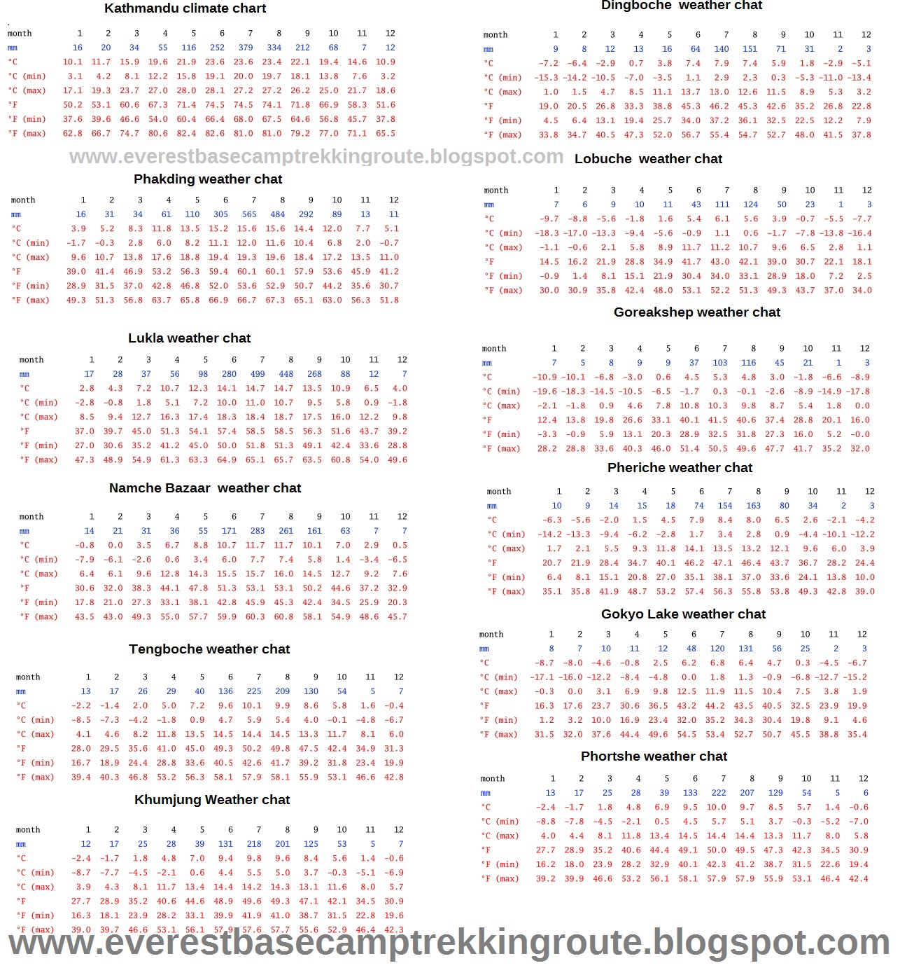
weather and climate in Everest Base Camp Trekking Route

With an altitude of 5200m, Everest Region  is generally the highest place common travelers can go. And right because of its extremely high altitude, climate and temperature of Everest Base Camp (EBC) is quite different from that of other places and regions.
Due to the rather high altitude, Mount Everest is covered by snow all year round and the climate here on the mountain is quite harsh. The most distinctive feature of the climate of EBC may be the extremely big temperature difference in the daytime and at night. And in different seasons and time, the climate and temperature also different . In winter, it can be snowy in EBC and that time hard to trek in Everest region. During June to August, it’s bit rainy season so in Lukla very High chances cancelled the flight, so you are not recommended to travel to EBC during that period. 
The best time to travel to EBC is from March to may and mid september to Mid december. During this time, the climate is relative good and the temperature is comparatively mild. But you should remember that, although in the daytime, with the sunshine, it can be warm at EBC with a possible temperature of around 10℃, it is quite cold at night which is sure to be below 0℃ even in summer.Monthly 

Here mention some important places climate chart in everest base camp trekking Route please enlarge for clicks  

Weather and climate chart for Everest Base camp trekking route


Festival in Everest region

Everest Base camp trekking route is famous for sherpas festival and other culture . In everest region especially from October to February, knows- how Khumbu transforms itself in the festive season from, the otherwise, dull and snowy region to an ever sparkling land of noisy and drunk inhabitants!
Famous for being the home of the tallest set of mountains in the world, Khumbu is also well known for its culture, traditions, people and most importantly, the celebrations.
So, for the explorers waiting curiously to shoot two birds with one arrow- trek to the Everest Base Camp and as well as experience a bit of a charm of local jamboree, here is the list of most celebrated festivals in the region.


Dumje


If you’re planning to make a visit to this region during May/ June, well, you’re up for a treat. Singing, dancing and heavy drinking is a general idea at this time because people all over Khumbu celebrate Dumje.
The ritual, initiated at Pangboche over 300 year ago, continues till this day with similar grace and enthusiasm. You can experience it at Tengboche, Namche Bazar, Khumjung, Pangboche and Junbesi of Solukhumbu. Among these, the festival in Namche is the most interesting and popular one.
Every year, a family from the village is chosen who, for 4 days, sponsors the festivities (food, drinks and pretty much everything). Important both religiously and socially, this festival is commemorated to mark the birth anniversary of high level Buddhist priest- Guru Rinpoche.

Mani Rimdu

It is the biggest festival celebrated in the Khumbu region or to be precise at Tengboche Monastery. The festival is celebrated in October which also happens to be the peak trekking season here in Nepal. A trip to the EBC at this time might be a good idea.
The 19 day celebration followed by masked dances, prayers, food and homemade wines sure looks fun! If your Everest Base Camp trek occurs in late October or early November, you may be able to witness this vibrant celebration at Tengboche Monastery.
Made famous by its rituals and the incredible atmosphere, generated by the whole community, the gathering seems promising enough to be a part of especially after a tough day on a trail.

Gyalpo Lhosar

Lhosar is the Tibetan New Year, a three- day festival that brings together sacred and secular practices – prayers, ceremonies, hanging prayer flags, folk dancing and partying. It is celebrated during February/ March. During the month before Lhosar, in Tibetan households, the eight auspicious symbols and other signs are drawn on walls with white powder. In monasteries, several protector deities are honored with devotional rituals. On the last day of the year, monasteries are elaborately decorated. In homes, cakes, candies, breads, fruits and beer are offered on family altars.

People and Culture in Everest Region

Sherpa people

Sherpas: Sherpa means "easterner" because they came from the Kham in eastern Tibet. One of the first persons to come to Khumbu came by way of the Rolwaling valley and Tashi Lhapcha pass. He opened this valley so other people could come to settle. Later many families came from Tibet over the Nangpa La (pass). He came to Khumbu from Kham Salmo-Gang (east of Tibet). His clan was called Thimi. When he came to Tibet, the people asked where he came from – “the cast part of Kham”. That is how the name Sher-pa, meaning east people, came to be....
For 600 years, people have migrated from Tibet to these mountain valleys in Nepal. There was a time of great unrest in Tibet when many Lamas, their families and followers left their homes looking for new places to live. They settled in the mountain valleys of northern Nepal. These places came to be called Yolmo (Helambu), Langtang, and Khumbu. Now they live in the Solu-Khumbu district, Sagarmatha zone of Nepal. They live in the highest places. In the Khumbu, they number about 9500 with a total of roughly 55,000 living in all of Nepal. The Sherpa language (a dialect of Tibetan), literature, history and Philosophy came from old Tibetan religious books.
Today approximately 55,000 Sherpas live in Nepal and around 9500 of them live in the Khumbu region on the south side of Everest. Since the 1950s, tourism has become the dominant source of employment and income in the area. Many Sherpas, as well as people from other ethnic groups, work as part of the climbing and tourism industry. While the Sherpa people retain their Buddhist religion and many of their traditional practices, this shift in the local economy and way of life has necessarily meant changes in the Sherpa culture. Among these, there has been a shift from regarding climbing the mountain as blasphemous, to regarding it as a source of economic opportunity and pride. Sherpas hold many impressive Everest records, including most times summitted for men and women, quickest ascent, without oxygen ascent, quickest descent, and most time spent on top and youngest climbers to reach the summit.

Sherpa Religion and Culture

In Solu-Khumbu the most common sect of Tibetan Buddhism is the Nyingmapa, the oldest tradition. Sherpa and Tibetan lamas taught this religion to the people and organized the communities.  These Sherpa and Tibetan Ngakpa (lay Lamas) brought teaching from Tibet to Khumbu that were from Books hidden by the founder of Tibetan Buddhism, Guru Rinpoche. Lamas called tertons are incarnations of Guru Rinpoche who rediscovered these hidden teachings. Ter means “spiritual treasure” in Tibetan. A lama named Rigdzin Godem found some of these books, the Chang-ter, hidden in northern Tibet. The other lama, Nyatak – Nyung, found the Lho-ter in southern Tibet. The terton, Terdak Lingpa found the books and wrote the texts used in the Sherpa’s Pujahs, religious rituals.
As more people came to Khumbu, traditions started that helped to unite the villagers and to project the valley. Daily life revolves around each village Gompa/Stupa (temple). Closely tied to Buddhist beliefs are their daily activates of farming, herding and trading. Since the 1950s they have worked for tourists and earned fame on climbing expeditions.   

Sherpa Language 

The Sherpa language is only a spoken language. There have been attempts in recent years to introduce a written form of this language based on the Tibetan script. But this is not an easy undertaking. The Sherpa language definitely goes back to a Tibetan dialect spoken in the eastern Tibetan Kham province in the 15th century, but it has developed in its own way for the last 500 years. So, it must be regarded as a language of its own separate from Tibetan. In modern times, Sherpa language has been enriched by a number of words taken from Nepali or English. Even within the Sherpa area one finds a lot of regional differences in the current use of the language. In Khumbu, for example, the use of words is a bit different from that of Pharak, Shorung (nep.: Solu), Helambu, Rolwaling, the Arun valley, Darjeeling etc. In the following list, the words have been written in the way they are used in Lhakpa's and Tendi’s home area, the Takshindu region of Shorung

Sherpa occupation 

Before 1959, most Sherpas farmed and traded with Tibet . The business with Tibet was usually for salt and wool. Today, most people work mountaineering, trekking, portering, or doing religious services. The old people spend some of their time saying whatever prayers they know, going around stone mani walls and village jha-khangs. and helping with their families.

Sherpa Food 

Potatoes, buckwheat, and barley are traditionally the main foods in Khumbu. Except for items brought up by traders, Sherpa food is limited to crops that can grow at the cold, high altitudes of the Khumbu. Sherpas eat some Tibetan foods, such as shykpa, tsampa (roasted barley flour), and some Nepali food such as dal bhat. Unique to the Sherpas are green vegetables that are cooked then fermented to keep, and kyu a sour or salty porridge of many grains-corns, rice, millet.
The Sherpas grow potatoes, buckwheat, barley turnips, and greens. Dairy products include butter, yogurt, and cheese. They purchase rice, lentils, corn, millet and fresh meat from down-valley traders at the market. Salt and dried sheep meat is obtained from traders coming from Tibet .

Sherpa Dress and appearance 

The traditional Sherpa clothing is similar to that of Tibetans. Most of their hats were distinctive to Solu-Khumbu. The basic garment of the Sherpas, the chuba, originated in the cold climate of Tibet . It is a warm ankle-length robe that is bound around the waist by a long sash. The chubás upper portion becomes a large pocket for everything from money to bowls. Unrolled, the sleeves extend beyond the fingertips. 
In the past, chubas were made from strips of hand-woven woolen cloth. Originally they were the un-dyed white color of the sheep's wool from Tibet . Later we started dying they started dying the wool black or brown. On trading trips to Tibet , people often wore sheep skin chubas, jackets or pants

Sherpa House 

When the Sherpas first came to Solu-Khumbu, their homes were bamboo huts. Gradually they changed to being half stone, half split wooden logs. Eventually they became stone houses, and later with two floors. At present, there are even some three and four story hotels and houses.  Windows have been the fastest changing par of Sherpa houses, with the introduction of glass panes and just recently skylights are being added warming them up considerably both in light and in warmth.
The design of the lha-khang (chapel) was brought from Tibet. In every home it serves as a reminder of spiritual matters. 
Usually the houses had simple windows with an opening in a wooden frame that closed by a small door. The wooden lattice windows became popular in Khumbu when a Tibetan carpenter was re-building Tengboche gompa after the earthquake in 1934 used this design of window. Sherpas copied this design, especially in their household lha-khang windows. 
There are so many lodges along the most popular trekking trails in Nepal that it makes sense to use the facilities, rather than camp in their yards. While these Tea Houses are definitely not the alpine lodge which are often the height of rustic luxury in other parts of the world, they are uniquely Nepali and are being upgrade very fast these days to include toilets, showers, comfortable beds and great food. The Tea Houses give you a deep insight into the lives of the hardy mountain sherpa people, because most are family-run and just extensions of their family home. The food is nourishing and hygienically prepared and the environment cozy and congenial. We have carefully selected the lodges/Tea Houses which belong to our climbing sherpas familie.


1/09/2016

Attraction of Everest region trekking route

Lukla Airport (2680 m ) 

Lukla airport 
Tenzing-Hillary Airport, also known as Lukla Airport, is a small airport in the town of Lukla, in Khumbu, Solukhumbu district, Sagarmatha zone, eastern Nepal. A program titled Most Extreme Airports, broadcast on The History Channel in 2010, rated the airport as the most dangerous airport in the world. In January 2008 the airport was renamed in honor of Sir Edmund Hillary and Sherpa Tenzing Norgay, the first people to reach the summit of Mount Everest and also to mark their efforts in the construction of this airport. 
The airport is popular because Lukla is the place where most people start the climb to Mount Everest Base Camp. There are daily flights between Lukla and Kathmandu during daylight hours in good weather. Although the flying distance is short, rain commonly occurs in Lukla while the sun is shining brightly in Kathmandu. High winds, cloud cover, and changing visibility often mean flights can be delayed or the airport closed. The airport is contained within a chain link fence and patrolled by the Nepal armed police or civil police around the clock. 

Namche Bazaar (3440 m ) 

Namche Bazaar located at the altitude of 3440 meters in the solukhumbu district. A Sherpa
Namche Bazaar 
community village Namche Bazaar is the main gateway for Everest trekking route, Peak climbing, expedition or others activities in Everest region. Namche bazaar is the Point especially for altitude acclimation for high Himalaya and it is the main trading center and tourist hub for the Khumbu region with many Nepalese officials, a police check, post and a bank. The village is full of the lodges, catering for visitors as well as numbers of internet cafes, making it one of the few places in the region where trekkers can access the internet. The main street into the village is lined with Tibetan run handicraft stalls and stores. 

Tengboche  Monastery(3867m). 

Tengboche Monastery is a famous Tibetan Buddhist monastery located in the Tengboche village in
Tengboche Monastery 
Khumjung. This monastery is also known as Dawa Choling Gompa. Situated at 3,867 meters (12,687 ft), the monastery is also the largest gompa in this region. The monastery was built in 1916 by Lama Gulu with strong links to its mother monastery known as the Rongbuk Monastery in Tibet. However, in 1934, it was destroyed by an earthquake and was subsequently rebuilt. In 1989, it was destroyed for a second time by a fire and then rebuilt with the help of volunteers and international assistance. In the background of this monastery there is a good view of Mt. Amadablam, Mt. Everest, Mt. Nuptse, Mt. Tawache, Mt. Thamserku, Mt. Lhotse and others.

In the Everest trekking area, apart from Tengboche monastery, other famous monasteries include: Thame, Khumjung and Pangboche.

Kala Patthar(5545 m) 

Kala Patthar 
Kala Pattar is Nepali name and it means 'black rock' in English, is a famous attraction located nearby the Everest base camp an altitude of 5545m on the south ridge of mount Pumori in the khumbu region.  Kala pattar is not the Mountain just a normal trekking peak.  Kala pattar is very popular peaks since it is one of the best viewpoint in the Everest Himalayan region, from there you can see beautiful panoramic views of the Himalayan range include Top of the world Everest from base  camp to summit (due to the structure of Everest, the peak cannot be seen from the base camp).  Mt Everest, Mt Nuptse, Mt Lhotse, Mt Pumori, Mt Amadablam, Mt Thamserku and many other snow capped mountains can be seen from kalapattar. 
The ascent of Kala Pattar begins from Gorakshep where the few teahouses are. Gorakshep is located on altitude of 5165m. and it is known as base camp of Kala pattar too. Gorakshep is the place where you can get lodging and fooding facilities on the Everest base camp trek. Further up from Gorakshep there is not any teahouse, so every trekker stays overnight there to explore around base camp and kala pattar. 
Climbing up to Kala pattar is not easy but doable by every trekker.  yes it is tough climbing, steep, narrow and rocky path, last ten minutes walk is risky over boulders to reach on top where is marked with many prayer flags. The ascent of Kala pattar usually takes 2 hours. It is all depend on your fitness level and how you are suffering from altitude

Everest base camp(5360 m ) 

Everest base camp (5360 meters) is probably the best trekking route In the world and it is not a
Everest Base camp 
wilderness expedition. Every year thousands of trekkers visited the Everest base camp. Famous for its spectacular mountain peaks and the loyalty and friendliness of its inhabitants (the Sherpas), the Everest region (Khumbu) is one of the most popular destinations for tourists in Nepal. Not only for trekking Everest has big history of climbing. So Base camp is the main acclimation point for the Everest summiteer. To visit the Everest base camp there are different option even those people who are Physically unable to trek to time duration to visit the Everest. In these condition the best way to visit the base camp is helicopter tour within a few hours visitors can visit the main attraction of the Everest.

Gokyo lake (4600-5100 m)

Gokyo lake, situated at the base of Mt. Everest and partially fed by the Ngozumpa glacier, is one of the most popular tourist destinations leading to Everest Base Camp in Sagarmatha (Everest) National Park. At an altitude of 4734 m, the lake is a source of permanent fresh water and has high hydrological values.Home to endangered species like snow leopard and musk deer, it also provides breeding ground for migratory birds. The Gokyo Lake is also considered a sacred lake for Hindus and Buddhists, where about 500 Hindu people take a holy bath during the Janai purnima festival, which usually occurs in the month of August. On an average 7,000 tourists annually visit the Gokyo Lake 
Gokyo lake system lies between the altitude ranges of 4600-5100 m in Khumjung VDC of Solukhumbu district, and is the main wetland site in the Park. The largest glacier Ngozumpa is the main sources of water for Gokyo. The wetland lies on the head of the Dudh Koshi River which descends from world's 7th highest mountains - Cho Oyo. There are five major lakes in Gokyo cluster, out of which Gokyo, also called Dudh Pokhari/ is the main lake (42 ha), followed by Taujon Cho (17 ha), Thonak Cho (65 ha), Ngozumpa Cho (14 ha) and Gyazumpa Cho (29 ha). The Gokyo lake feeds waters from various sources such as seepage from the Ngozumpa glacier, a stream coming from the Renjo La pass from north-west and another stream originating from the Ngozumpa glacier in the east. It is a glacier-fed freshwater wetland and discharges water to the Dudh Koshi River headway via the Taujun Lake and the Longabanga lake. No direct/visual connection between the Gokyo Lake and the upper Thonak Cho and the Ngozumpa Cho has been observed but these lakes may be connected via underground seepage water. The margins of the Gokyo Lake which is connected with streams in the form of inlets and outlets create marshes or
swamps along their marginal meadows

chola pass (5420 m)  

Cho La is a summit pass located 5,420 metres (17,782 ft) above sea level in the Solukhumbu District in northeastern Nepal. It connects the village of Dzongla (4,830 metres (15,850 ft)) to the east and the village of Thangak (4,700 metres (15,400 ft)) to the west.
The pass is on Gokyo trail, one of the popular and challenging trekking trails in Khumbu Everest region. To the west the trail continues to Gokyo Lakes crossing Ngozumpa glacier on the way. To the east the trail joins the Everest Base Camp trek.The pass can be physically demanding and may require crampons on top of a slippery glacier. The edge of the glacier is unstable.

Everest (8848 m) 

Everest 
Mount Everest, also known in Nepal as Sagarmāthā and in Tibet as Chomolungma, is Earth's highest
mountain. It is located in the Mahalangur section of the Himalayas. Its peak is 8,848 metres (29,029 ft) above sea level and is the 5th furthest summit from the center of Earth.
At 11:30 a.m. on May 29, 1953, Edmund Hillary of New Zealand and Tenzing Norgay, a Sherpa of Nepal, become the first explorers to reach the summit of Mount Everest, which at 29,035 feet above sea level is the highest point on earth.

 Ngozumpa glacier

The Ngozumpa glacier, below the sixth highest mountain in the world Cho Oyu in Nepal, at 36 kilometres (22 mi), is the longest glacier in the Himalayas. Ngozumpa Glacier is a large persistent body of ice. It flows slowly due to stresses induced by its weight.
The Nepali Himalayas are warming significantly in recent decades. Ngozumpa glacier is showing signs of shrinking and thinning, producing melt water. Some of this water pools on the surface where an enormous lake is growing. This lake, called Spillway, has the potential to be about 6 kilometres (3.7 mi) long, 1 kilometre (0.62 mi) wide and 100 metres (330 ft) deep.In the future this might be a threat to the Sherpa villages down the valley.

Khumbu Icefall ( 5,486)  

The Khumbu Icefall is located close to the Mount Everest base camp when approaching the mountain from the south. All climbers from the south need to pass this glacier because it blocks the way further up the silent valley (western cwm) , the main route to Mount Everest and also Lhotse.
The Khumbu Icefall is especially dangerous. The glacier moves with up to one meter every day which causes huge crevasses to appear almost from one second to the other. 2014 the so far largest catastrophe occurred here with 16 Sherpas dead.

Sagarmatha National Park 

Sagarmatha National Park covers the highest peak in the world, Mount Everest at 8,848 m, and its surrounding high mountain ranges. It is an area of geologically young mountains with sharp peaks and glaciers. The Dudh Kosi river originates here. Gokyo Valley (a RAMSAR site) has a number of lakes.
The park is located in north-eastern Nepal, in the Solo-Khumbu region.It encompasses an area of 1,148 km2 and ranges in elevation from its lowest point of 2,845 m at Jorsalle to 8,848 m at the summit of Everest. Most part of the land is barren, with grazing lands on the lower elevations. There are relatively few mammal species due to evolutionary factors.
Sagarmatha National Park is also home to about 3000 Sherpas. They moved there from Tibet some 500 years ago and keep up their distinct traditions and Tibetan-Buddhist religion

Sherpa People and Culture

Everest region is the home of Sherpas. Sherpas are an ethnic group of Nepal. They are migrated from Kham region of eastern Tibet within the last 300-400 years. Most of the people who are working in mountaineering and expeditions belong to this ethnic group. They are highly regarded as elite mountaineers and experts in their local terrain. They speak their own language. The Sherpa language belongs to the south branch of the Tibetan language family. This language is however not intelligible for Lhasa Tibetan speakers. During Everest trekking you will visit villages of Sherpas and have the opportunity to see their real lifestyle, traditions and culture.

Flora

In Everest region you will find varieties of flora and fauna. In the lower forested zone, birch, juniper, blue pines, firs, bamboo and rhododendron grow. Above this zone all vegetation are found to be dwarf or shrubs. As the altitude increases, plant life is restricted to lichens and mosses. Plants stop growing at about 5,750 meters (18,860 ft), because this is the permanent snow line in the Himalayas.

Fauna


The forests of Sagarmatha National Park provide habitat to at least 118 species of birds, including Himalayan Monal, Blood pheasant, Red-billed chough, and Yellow-billed chough. This park is also home to a number of rare mammal species, including musk deer, snow leopard, Himalayan black bear and red panda. Himalayan thars, Langur monkeys, martens and Himalayan wolves are also found in the park.

1/08/2016

Jiri to Ranjo la Pass Trekking route

Outline Itinerary of Jiri to Ranjo la Pass Trekking route  

Day 01 : Arrive in kathmandu (1400 M)
Day 02: Kathmandu Valley Tour, Trek Preparation (1400 M) 
Day 03: Scenic Drive to Bhandara (2190m ) via Jiri (1905m.) 
Day 04: Bhandar to Sete(2575m)
Day 05: Sete to Junbesi (2680m.) 
Day 06: Junbesi trek to Nunthala (2220m.) 
Day 07: Nunthala to Bupsa (2360m.) 
Day 08: Bupsa to surke (2796m.) 
Day 09: Surke to Phakding (2610m.) 
Day 10: Phakding to Namche Bazaar (3440m) 
Day 11: Acclimatization day in Namche Bazaar 
Day 12: Namche to Phortse Thanga (3680m.) 
Day 13: Phortse Thanga to Machhermo (4470m.) 
Day 14: Machhermo to Gokyo (4800m.) 
Day 15: Rest day at Gokyo 
Day 16: Cross Renjo La Pass (5400m.)and trek to Lunde 
Day 17: Lunde to Thame 
Day 18: Thame to Namche 
Day 19 : Namche Bazaar to Lukla 
Day 20: Fly back Lukla to Kathmandu (1310m) 35 min flight
Day 21: Leisure day in Kathmandu
Day 22: Departure


Detail Itinerary of Jiri to Ranjo la Pass Trekking route  

Day 01 : Arrive in kathmandu (1400 M) 
Arrive in Kathmandu airport and we will meet and  transferred to hotel. Evening time explore Thamel yourself and overnight at hotel in Kathmandu

Day 02: Kathmandu Valley Tour, Trek Preparation (1400 M) 
Take a morning tour of Kathmandu city after breakfast, and see all the main sights of the Kathmandu Valley, including the Boudhanath Stupa, Pashupatinath Temple, Swayambhunath Stupa (Monkey Temple), and Durbar Square. and discuss about the trekking for any final checks of your trekking equipment and clothing (sleeping bags, jacket, boots etc.).

Day 03: Scenic Drive to Bhandara (2190m ) via Jiri (1905m.) 
Driving distance 187 kms – Approximately 8  Hours drive by local bus 
Today we take an early morning drive to Jiri, about 187 km north-east of Kathmandu. Since, we would be travelling on the mountain roads, it takes around 6-7 hrs to reach Jiri. From Jiri, we continue driving to Bhandar, our trek start point. Enjoy the views of Kosi River and panoramic views of the eastern Himalaya including Ganesh Himal, Langtang Lirung and Dorje Lakpa. 

Day 04: Bhandar to Sete(2575m)
Trekking distance ----kms – Approximately  7  Hours walk  
Jiri is also known as the Switzerland of Nepal. It is very beautiful place. The beginning of  trek is a gentle ascent for the first two hours to Mali Danda (2440m.) and then it follows a gently descending path to Shivalaya (1800m.) After Shavalaya  the trail turns steeply up before turning into a gentle ascent to Deurali. You can enjoy the green scenery as well as some of the snow-capped mountains at a far distance.

Day 05: Sete to Junbesi (2680m.) 
Trekking distance ----kms – Approximately  7  Hours walk 
From Sete we gradually ascend to the Lamjura Pass (3530m.). From the Lamjura Pass we can see the panoramic view of the surrounding mountains. We cross it and then descend through the rhododendron, fir pine, magnolia, maple and birch forest and finally reach Junbesi. 

Day 06: Junbesi trek to Nunthala (2220m.) 
Trekking distance ----kms – Approximately  7  Hours walk 
This day we cross the Junbesi Khola and then walk in the ascending slope through the forest. After some hours of climbing we see the amazing view of the mountains like Everest, Lhotse, Nupte, Makalu, Thamserku, Mera Peak, and many more. We continue the trail to Salung and then descend to Ringmo Khola. Again we walk up hill and cross Trakshindo La pass and finally descend down to Nunthala through the conifer and rhododendron forests, and terraced fields. 

Day 07: Nunthala to Bupsa (2360m.) 
Trekking distance ----kms – Approximately  7  Hours walk 
This day also we continue climbing down to the Dudh Koshi River. Then we follow the Dudh Koshi River and walk up ward to Khumbu. Then we climb to Jubing. From there we walk straight and descend to cross a suspension bridge and finally ascend to Bupsa Danda. 

Day 08: Bupsa to surke (2796m.) 
Trekking distance ----kms – Approximately  6  Hours walk 
The beginning of your trek is a gentle descent to the Dudh Koshi river (Milk River) for an early two hours passing through agricultural farm land and small Sherpa and Rai settlements. From the Dudh Koshi river, your trail is a gentle ascent all the way to Kharikhola (2050m.) passing through Juving (1680m.) a pretty big Rai village and farming lands. From Kharikhola your trail follows a flat path for 45 minutes and then steeply up to the camp (Bupasa) where you can visit a Buddhist Monastery 

Day 09: Surke to Phakding (2610m.) 
Trekking distance ----kms – Approximately  6  Hours walk 
The first part of the trek is a gentle ascent for early 2 hours to Chhiplung (2700m.), a junction road to Jiri and Lukla passing through Mushe (2650m.). From this place, the road is quite broad and busy. Now, your trail is almost flat and gently descends before ascending again to Phakding. This is a short trek after 3 long days on the trail. You can hang in and around Phakding village.

Day 10: Phakding to Namche Bazaar (3440m) 
Trekking distance 10.5km approximately 6 Hours walks.
After breakfast start trekking through a beautiful pine forest that leads us along the Dudh Koshi River and Hillary Suspension Bridge to reach to Monjo and starting point of Sagarmatha National Park. Here we stop at check post of TIMS & National Park permit. The trail passes through the Dudh Koshi, Bhote Koshi River, Jorsale village, Large Dovan and cross one of the highest bridge over the Dudh Kosi River of Everest region and reach to Chautara from where we can see the first glimpse of the Mt. Everest. Further walking about one hour steep up we reach to Namche bazar. Namche bazar is one of the trading points for Sherpa people. It is also ideal market for visitors to purchase traditional crafts. If you missed any trekking gears don't worry you can buy some trekking gears over here as well. Every Saturday there would be local street market, do not miss if you are there on Saturday.

Day 11: Acclimatization day in Namche Bazaar 
Today is the schedule for acclimatization. However, we do not spend worth less at the lodge. It is highly suggested to climb up and stay overnight at low altitude so our body can adjust the high altitude climate. In the morning visit near by attraction; Sherpa Culture Museum and Everest photo Gallery, which is just 15-minute walking distance from Namche Bazar. From the museum you can have the spectacular picturesque Mountain View and take some photographs. Then start trekking to Everest view hotel passing through Syangboche Airport (3700m), which is situated at the highest altitude, takes about 2 hours. We climb further to reach Mt. Everest View Hotel for great panoramic views of Mt. Everest, Lhotse, Ama Dablam, Tawache, Kusum Kangkaru, Thamserku, Kongde and many more. Enjoy the spectacular view of mountains including Mt. Everest from the nearest destination then trek back to Namche Bazar.

Day 12: Namche to Phortse Thanga (3680m.) 
Trekking distance 10 km approximately 5 Hours walks.
This day we leave Namche bazaar and walk for some time along the ridge. We climb steeply out iof the valley through the forest of rhododendron and Juniper. We cross yak Kharkas which is the summer settlements of Sherpa. And finally we reach Phortse Thanga where we stay overnight. 

Day 13: Phortse Thanga to Machhermo (4470m.) 
Trekking distance 13 km approximately 6 Hours walks.
This day at first we climb through a ridge and then descend to the valley Kengtega enjoying the panorama of the mountains. then we again climp up towards Cho Oyu and descend to a river and again climbs steep to the terminal moraine of the Ngozumpz glacier. We will reach at Machhermo by early noon. 

Day 14: Machhermo to Gokyo (4800m.) 
Trekking distance 7 km approximately 5 Hours walks
Today the trek takes us at one of our final destination, Gokyo (4790m.).we climb through a ridge Chorten from where we can see fabulous view of both down the valley and of the Mt. Kangtega, Thamserku, and northern part to the Cho-Oyu (8153m.). 

Day 15: Rest day at Gokyo 

View from Gokyo Ri 
  
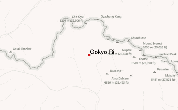
This day early in the morning we have a steep climb up to the top of Gokyo Ri (5350m) – ample rewards to ones that attempt this trip. There are stunning views of the Gokyo valley, the massive Ngozumpa Glacier and an incredible panoramic view of the whole Khumbu Himalayas, such giants as Everest, Lhotse, Nuptse, Makalu (8481m), Cho-Oyu (8201m) and Gychung Kang (7922m). This day we have for acclimatization, back to the camp in the afternoon and have some tea and biscuits. Hiking up the valley to see the fourth and fifth lakes is great as well.

Day 16: Cross Renjo La Pass (5400m.)and trek to Lunde 
Trekking distance ------ Kms Approximately 6 Hours
This day early in the morning we cross the Renjo La pass. From the pass, we can see the views of Everest, Lhotse and surrounding mountains. We also see the beautiful scenery of the Gokyo Lake and Gokyo village below the Ngozumba glacier. From the pass we descend down on a stone staircase to Lunde where we stay overnight.

Day 17: Lunde to Thame 
Trekking distance ------ Kms Approximately 5 Hours
This day we trek down to Thame, a sprawling village. From Thame we can see the stunning views of the mountains like Thamserku, Kantenga, Kusum Kangguru etc. here you can explore the village and visit monastery established around 300 years ago.

Day 18: Thame to Namche 
Trekking distance ------ Kms Approximately 6 Hours
Today, we begin our walking in the flat trail and then descending to Thamo. In Thamo you can visit the Khari Gompa where you find Nuns and Monks. Then we head to Namche bazaar. 

Day 19 : Namche Bazzar to Lukla 
Trekking distance 15 Kms / Approximately 8 Hours
Finally we return to Lukla where the trek began, which will seem like a lifetime ago. Enjoying time to reflect on the trek as a group and the personal achievement of all those who took part. Also giving you time to explore the town.

Day 20: Fly back Lukla to Kathmandu (1310m) 35 min flight

Fly from Lukla to Kathmandu will take 30 minutes of amazing scenic mountain flight lands you in the domestic terminal of the airport. Up on arrival in Kathmandu, transfer to the hotel and in the afternoon enjoys as leisure. Remember there is high chance of cancelling flight because of the weather condition. We do have some evidence trekkers had to stay for 3 days because of the weather condition. So be prepared and make one leisure day in Kathmandu so that you can be safe.

Day 21: Leisure day in Kathmandu

It's also spare day in case of bad weather in Lukla. Remember, there are high chances of cancelling flights because of weather condition in Lukla. You have option to stroll around the local tourist market in Kathmandu to observe the living style of local people in Kathmandu valley. You can observe the traditional houses, arts and crafts, local people selling clothes, fruits and vegetable around Indrachook and Ashanon located on the North Part of the Kathmandu Durbar Square.

Day 22: Departure
Transfer to the airport by private vehicle according to your flight schedule.


Jiri to Gokyo lake trekking route


Outline itinerary Of Jiri to Gokyo lake trekking route 


Day 01 : Arrive in kathmandu (1400 M) 
Day 02: Kathmandu Valley Tour, Trek Preparation (1400 M) 
Day 03: Scenic Drive to Bhandara (2190m ) via Jiri (1905m.) 
Day 04: Bhandar to Sete(2575m)
Day 05: Sete to Junbesi (2680m.) 
Day 06: Junbesi trek to Nunthala (2220m.) 
Day 07: Nunthala to Bupsa (2360m.) 
Day 08: Bupsa to surke (2796m.) 
Day 09: Surke to Phakding (2610m.) 
Day 10: Phakding to Namche Bazaar (3440m) 
Day 11: Acclimatization day in Namche Bazaar 


Day 12: Namche to Phortse Thanga (3680m.) 
Day 13: Phortse Thanga to Machhermo (4470m.)
Day 14: Machhermo to Gokyo (4800m.) 
Day 15: Rest day at Gokyo 
Day 16 : Gokyo lake to Dole ( 4040 m ) 
Day 17: Dole to Namche Bazaar 
Day 18 : Namche Bazzar to Lukla 
Day 19: Fly back Lukla to Kathmandu (1310m) 35 min flight
Day 20: Leisure day in Kathmandu
Day 21: Departure


Detail itinerary Of Jiri to Gokyo lake trekking route 
Day 01 : Arrive in kathmandu (1400 M) 
Arrive in Kathmandu airport and we will meet and  transferred to hotel. Evening time explore Thamel yourself and overnight at hotel in Kathmandu

Day 02: Kathmandu Valley Tour, Trek Preparation (1400 M) 
Take a morning tour of Kathmandu city after breakfast, and see all the main sights of the Kathmandu Valley, including the Boudhanath Stupa, Pashupatinath Temple, Swayambhunath Stupa (Monkey Temple), and Durbar Square. and discuss about the trekking for any final checks of your trekking equipment and clothing (sleeping bags, jacket, boots etc.).

Day 03: Scenic Drive to Bhandara (2190m ) via Jiri (1905m.) 
Driving distance 187 kms – Approximately 8  Hours drive by local bus 
Today we take an early morning drive to Jiri, about 187 km north-east of Kathmandu. Since, we would be travelling on the mountain roads, it takes around 6-7 hrs to reach Jiri. From Jiri, we continue driving to Bhandar, our trek start point. Enjoy the views of Kosi River and panoramic views of the eastern Himalaya including Ganesh Himal, Langtang Lirung and Dorje Lakpa. 

Day 04: Bhandar to Sete(2575m)
Trekking distance ----kms – Approximately  7  Hours walk  
Jiri is also known as the Switzerland of Nepal. It is very beautiful place. The beginning of  trek is a gentle ascent for the first two hours to Mali Danda (2440m.) and then it follows a gently descending path to Shivalaya (1800m.) After Shavalaya  the trail turns steeply up before turning into a gentle ascent to Deurali. You can enjoy the green scenery as well as some of the snow-capped mountains at a far distance.

Day 05: Sete to Junbesi (2680m.) 
Trekking distance ----kms – Approximately  7  Hours walk 
From Sete we gradually ascend to the Lamjura Pass (3530m.). From the Lamjura Pass we can see the panoramic view of the surrounding mountains. We cross it and then descend through the rhododendron, fir pine, magnolia, maple and birch forest and finally reach Junbesi. 

Day 06: Junbesi trek to Nunthala (2220m.) 
Trekking distance ----kms – Approximately  7  Hours walk 
This day we cross the Junbesi Khola and then walk in the ascending slope through the forest. After some hours of climbing we see the amazing view of the mountains like Everest, Lhotse, Nupte, Makalu, Thamserku, Mera Peak, and many more. We continue the trail to Salung and then descend to Ringmo Khola. Again we walk up hill and cross Trakshindo La pass and finally descend down to Nunthala through the conifer and rhododendron forests, and terraced fields. 

Day 07: Nunthala to Bupsa (2360m.) 
Trekking distance ----kms – Approximately  7  Hours walk 
This day also we continue climbing down to the Dudh Koshi River. Then we follow the Dudh Koshi River and walk up ward to Khumbu. Then we climb to Jubing. From there we walk straight and descend to cross a suspension bridge and finally ascend to Bupsa Danda. 

Day 08: Bupsa to surke (2796m.) 
Trekking distance ----kms – Approximately  6  Hours walk 
The beginning of your trek is a gentle descent to the Dudh Koshi river (Milk River) for an early two hours passing through agricultural farm land and small Sherpa and Rai settlements. From the Dudh Koshi river, your trail is a gentle ascent all the way to Kharikhola (2050m.) passing through Juving (1680m.) a pretty big Rai village and farming lands. From Kharikhola your trail follows a flat path for 45 minutes and then steeply up to the camp (Bupasa) where you can visit a Buddhist Monastery 

Day 09: Surke to Phakding (2610m.) 
Trekking distance ----kms – Approximately  6  Hours walk 
The first part of the trek is a gentle ascent for early 2 hours to Chhiplung (2700m.), a junction road to Jiri and Lukla passing through Mushe (2650m.). From this place, the road is quite broad and busy. Now, your trail is almost flat and gently descends before ascending again to Phakding. This is a short trek after 3 long days on the trail. You can hang in and around Phakding village.

Day 10: Phakding to Namche Bazaar (3440m) 
Trekking distance 10.5km approximately 6 Hours walks.
After breakfast start trekking through a beautiful pine forest that leads us along the Dudh Koshi River and Hillary Suspension Bridge to reach to Monjo and starting point of Sagarmatha National Park. Here we stop at check post of TIMS & National Park permit. The trail passes through the Dudh Koshi, Bhote Koshi River, Jorsale village, Large Dovan and cross one of the highest bridge over the Dudh Kosi River of Everest region and reach to Chautara from where we can see the first glimpse of the Mt. Everest. Further walking about one hour steep up we reach to Namche bazar. Namche bazar is one of the trading points for Sherpa people. It is also ideal market for visitors to purchase traditional crafts. If you missed any trekking gears don't worry you can buy some trekking gears over here as well. Every Saturday there would be local street market, do not miss if you are there on Saturday.

Day 11: Acclimatization day in Namche Bazaar 
Today is the schedule for acclimatization. However, we do not spend worth less at the lodge. It is highly suggested to climb up and stay overnight at low altitude so our body can adjust the high altitude climate. In the morning visit near by attraction; Sherpa Culture Museum and Everest photo Gallery, which is just 15-minute walking distance from Namche Bazar. From the museum you can have the spectacular picturesque Mountain View and take some photographs. Then start trekking to Everest view hotel passing through Syangboche Airport (3700m), which is situated at the highest altitude, takes about 2 hours. We climb further to reach Mt. Everest View Hotel for great panoramic views of Mt. Everest, Lhotse, Ama Dablam, Tawache, Kusum Kangkaru, Thamserku, Kongde and many more. Enjoy the spectacular view of mountains including Mt. Everest from the nearest destination then trek back to Namche Bazar.

Day 12: Namche to Phortse Thanga (3680m.) 
Trekking distance 10 km approximately 5 Hours walks.
This day we leave Namche bazaar and walk for some time along the ridge. We climb steeply out iof the valley through the forest of rhododendron and Juniper. We cross yak Kharkas which is the summer settlements of Sherpa. And finally we reach Phortse Thanga where we stay overnight. 

Day 13: Phortse Thanga to Machhermo (4470m.) 
Trekking distance 13 km approximately 6 Hours walks.
This day at first we climb through a ridge and then descend to the valley Kengtega enjoying the panorama of the mountains. then we again climp up towards Cho Oyu and descend to a river and again climbs steep to the terminal moraine of the Ngozumpz glacier. We will reach at Machhermo by early noon. 

Day 14: Machhermo to Gokyo (4800m.) 
Trekking distance 7 km approximately 5 Hours walks
Today the trek takes us at one of our final destination, Gokyo (4790m.).we climb through a ridge Chorten from where we can see fabulous view of both down the valley and of the Mt. Kangtega, Thamserku, and northern part to the Cho-Oyu (8153m.). 

Day 15: Rest day at Gokyo 

View from Gokyo Ri 
This day early in the morning we have a steep climb up to the top of Gokyo Ri (5350m) – ample rewards to ones that attempt this trip. There are stunning views of the Gokyo valley, the massive Ngozumpa Glacier and an incredible panoramic view of the whole Khumbu Himalayas, such giants as Everest, Lhotse, Nuptse, Makalu (8481m), Cho-Oyu (8201m) and Gychung Kang (7922m). This day we have for acclimatization, back to the camp in the afternoon and have some tea and biscuits. Hiking up the valley to see the fourth and fifth lakes is great as well.

Day 16 : Gokyo lake to Dole ( 4040 m ) 
Trekking distance 8 Kms / Approximately 7 Hours
The way  from Gokyo to dole  is an easy downhill walk along the Dudh Koshi River that emerges out of the Ngozumpa Glacier. Passing by the second and then the first Gokyo Lakes, we come to a small gushing stream over an iron bridge. We see the hamlet of Phangka ahead. Cholatse and Taboche peaks rear up on the right of us. The trail descends below Phangka, and across a level terrace on the slope to climb a rib on the far side of the hill side. Upon reaching the Chorten at the edge, we see great views of Thamserku , Cho Oyu, and Kangtega. We slowly walk down to sprawling village of Machhermo. Again, through the charming hamlet of Luza and Lhafarma we reach Dole. 

Day 17: Dole to Namche Bazaar 
Trekking distance 13 Kms / Approximately 6 Hours
After breakfast trek from Dole to Monjo village, which will take approximately 6 hours. From Dole the trail drops sharply down to the Dudh Kosi River after long walk  reach to Phortse Thangka. We ascend steep up to Mongla Hill (3973m) for about one and half hour. From Mongla Hill offers you the excellent views of Aama Dablam, Thamserku, Kusum Kangkaru, Kongde Ri and Tawache peak. At Mongla Hill enjoy the leisurely lunch exploring the panoramic mountain views. Descent to the Sanasa and retrek  to Namche bazzar 

Day 18 : Namche Bazzar to Lukla 
Trekking distance 15 Kms / Approximately 8 Hours
Finally we return to Lukla where the trek began, which will seem like a lifetime ago. Enjoying time to reflect on the trek as a group and the personal achievement of all those who took part. Also giving you time to explore the town.

Day 19: Fly back Lukla to Kathmandu (1310m) 35 min flight
Fly from Lukla to Kathmandu will take 30 minutes of amazing scenic mountain flight lands you in the domestic terminal of the airport. Up on arrival in Kathmandu, transfer to the hotel and in the afternoon enjoys as leisure. Remember there is high chance of cancelling flight because of the weather condition. We do have some evidence trekkers had to stay for 3 days because of the weather condition. So be prepared and make one leisure day in Kathmandu so that you can be safe.

Day 20: Leisure day in Kathmandu
It's also spare day in case of bad weather in Lukla. Remember, there are high chances of cancelling flights because of weather condition in Lukla. You have option to stroll around the local tourist market in Kathmandu to observe the living style of local people in Kathmandu valley. You can observe the traditional houses, arts and crafts, local people selling clothes, fruits and vegetable around Indrachook and Ashanon located on the North Part of the Kathmandu Durbar Square.

Day 21: Departure
Transfer to the airport by private vehicle according to your flight schedule.